Tuesday, January 21, 2014

Nature Reclaimed: The Hookton Slough at Humboldt Bay National Wildlife Refuge


Date: July 7, 2013
Place: Humboldt Bay National Wildlife Refuge, Loleta, California
Coordinates:  40.6774, -124.2219
Length: 3 miles in and out
Difficulty: easy

Our morning hike of the Shorebird Loop Trail was not enough for us. After a short lunch break we drove around the Humboldt Bay National Wildlife Refuge to the Hookton Slough Unit and embarked on the Hookton Slough Trail.
Map copied from Hamboldt Bay NWR brochure. Our trail is labeled yellow.
150 years ago, Hookton Slough used to be an active port. Boats used to go up the slough and dock there, right where we parked our car. Carts would ride the dirt, sometimes muddy, roads that connected the town to the port, and the place was busy with human activity.
Hookton Slough, view east
Today, very little remains of all that commerce activity that once took place at Hookton. There is a dock there all right, where people take their kayaks to the water.
We just walked on the trail that stretches along the slough on its southern bank.
Hookton Slough, view west
The trail is completely level, wide and super easy to walk. Even so, we hiked it slowly, because it is also rich with wildlife and other pretty sights.
Pale Swallowtail
The grey overcast was starting to thin out. There was still enough of it though, to make a good background for a flying heron.
Great Blue Heron
There were many weeds in bloom along the trail. Most of them were invasive crucifer species. On the water side there were clusters of cloud-white blossoms: the prevalent California native narrow-leaf milkweed.
Common Yarrow (Achillea millefolium)
 Going out west, I paid more attention to the water side of the trail. Besides the milkweed I took notice of the lichen-decorated levee rocks and the salt marsh swamp fire plants that grew between them.
Lichen and Pacific Swampfire (Salicornia pacifica)
The wind kept blowing in our faces as we headed west. None better to demonstrate that than the flexible blossoms of the tuft grass. The yellowish tips shined and sparkled against the grey background. I couldn't quite capture that effect on camera.
Tuft Grass (Deschampsia caespitosa ssp. holciformis)
A group of great egrets blocked our way. They seemed to have been discussing some serious matter between themselves. As we drew near they flew a bit further down the trail. They did so again and again as we progressed down the trail. Eventually, they flew away altogether.
Great Egret
I looked south. A dark grove of trees far across the field was there, carrying a large number of roosting egrets and herons.


A few more steps and I run into what could possibly have been the point of discussion: a broken egg shell.
 
And another. And another. That entire section of trail was decorated with numerous broken eggs in varying degrees of shatter. Some had still dried yolk smeared on them, suggesting that they were stolen from the nest and eaten, rather than the shells being the removed remains of hatched eggs. The eggs are a but smaller and more slender than an ordinary chicken egg and I suspect they might have originated at the heron colony in that far away grove.
We went on walking. The tide, that was receding the entire time we were walking west, has reached its lowest point and we were nearing the end of the trail.
The changing of the tides at the Hookton Slough. 
Our hike ended abruptly at a gate carrying the sign 'End of Trail'. The trail does continue, however, into private land.
The view beyond the end of Hookton Slough Trail
We stayed there for sometime. The chikas went down to the exposed tidal zone and drew pictures in the sand. As appreciative as I am of my daughters' artwork, I do prefer the natural ripples pattern etched in the sand.
Low tide
Eventually it was time to head back. The sun was making good progress in breaking through the overcast, the tide was coming in now and the smaller birds were all over the place, looking pretty:
Cedar Waxwing
And sounding great:
Song Sparrow
It was only on the way back that I noticed a canal of what looked like fresh water on the east side of the trail. I looked closely, but couldn't see anything swimming there.


The way back didn't yield any more surprises. The chickas were busy looking for ladybugs and snails. They even found some :-)
European Brown Snail
Before long we were back at the parking lot and done with our Forth of July vacation. It was 4 hours of quiet drive all the way back to the Bay Area.


Many thanks to members of the California Native Plants Society for their help in identifying plants!


You can click on the photos to get a better view.


Thursday, January 16, 2014

Things I saw in the Slough: Hiking at Humboldt Bay NWR


Date: July 7, 2013
Place: Humboldt Bay National Wildlife Refuge, Loleta, California
Coordinates:  40.6861, -124.2124
Length: 1.75 miles
Difficulty: easy
Comment: bring mosquito repellant.

Map copied from Hamboldt Bay NWR brochure. Our trail is labeled yellow.


The last night of our 4th of July trip we spent in the coastal town of Eureka. We woke up to the chill of a foggy morning which, after the intense heat of Willow Creek, was a much welcomed relief. After a quick breakfast we headed straight to the sole destination we planned for that day: the Humboldt Bay National Wildlife Refuge.


After a short visit to the visitor center we went out on our first trail: the Shorebird Loop Trail, that begins right behind the building.   For about half a mile the trail meanders along a narrow slough. Close to the beginning there is a small observation hut.
A Black-crowned Night Heron on the little foot bridge behind the visitor center
By the time we were there I already had to run twice back to the car to get the chicka's sweater and the bug repellant. Throughout the hike we were walking through a cloud of hungry mosquitoes. We needed the protection.

The ground, even on the trail itself, was completely covered with green vegetation. Many plants were blooming.


Most of what I've seen in bloom were invasive plant species.
Bull Thistle (Cirsium vulgare). Non-native, invasive.
Nonetheless, the flowers were very pretty.
Common Brassbuttons (Cotula coronopifolia). Non-native, invasive.


After half a mile the trail splits and loops around a large pond. The calm water was closely watched by egrets and herons.
Great Egret
The dense cattail thicket provided shelter to many birds. We heard them well enough. On occasions, we saw them too.
Mallard chicks speeding after their camera-shy mother 
If they stayed long enough above the water, that is.
Pied-billed Grebe
The pond water was so calm, like a perfect mirror. It is difficult to select from the many beautiful reflections I photographed that day.

We walked slowly, imbibing the sights and sounds carried by the thick, humid air. As always, the chickas were quick to spot the ground crawlers on the trail.
Stop the traffic! I'm crossing! 
Or those winged ones that just sopped for a rest, like this moth:
 Red-shouldered Ctenucha (Ctenucha rubroscapus)

Bu then the elder chicka made a much more important find: A Virginia Rail that stepped momentarily out of the cattails.
Virginia Rail
Rails aren't that rare. They are, however, very difficult to see. They spend nearly all of their time hiding in the thicket. Needless to say, Papa Quail got very excited about the rail and the chicka was very proud of herself for having spotted it in the first place. In fact, she kept going on and on for the rest of that day about finding a rail for Papa :-)
The trail continues beyond the pond and near the slough that extends from Humboldt Bay. It was low tide and the mud flats were criss-crossed with bird tracks. The birds themselves were no longer there.

We looped back and neared the canal once again.

I was looking at the weeds that were blooming along the canal banks, coloring it with whites, pinks and yellows, and rendering those very same colors to the murky water below.

And it was there, in the canal, while I appreciated the flowers, that I saw something brown swimming. Sure enough: there was a pair of river otters! Right there in front of our eyes!
River Otter
We were very excited, of course. The otters were less excited and swam off.
River Otter
It was a very good hike for viewing wildlife. While there wasn't as much excitement as with the rail and the otters, we were very happy to see the Black-tailed Deer in the meadow behind the canal.
Black-tailed Deer
And as always, the small, pretty singers who hummed all around us while we hiked.
Song Sparrow
At that point were were getting back into mosquito-dom and found out that one layer of bug repellant was not enough. Each of us was sporting quite a few bites. We hurried to the end of the trail.
Black-capped Chickadee busy seed-tasting. 
What can I say? Mosquito bite, plenty enough to play connect-the-dots on our skins were a small price to pay for the chance to walk in this beautiful refuge and to see its rich wildlife.
American Goldfinch, male
We had enough of the mosquitoes but not of the Humboldt Bay NWR. So we packed ourselves and drove around to the other side of the park where, after a quick lunch, we embarked on another hike along the Hookton Slough.


Many thanks to members of the California Wildlife Appreciators for their help in identifying the moth!


A few months after that trip my elder chicka was still talking about the Virginia Rail she had sighted. Being the artist she is, she drew a painting of the rail and added a few avian friends too :-)


Saturday, January 11, 2014

Excitement at the Vista Peak Loop Trail of Garin Regional Park


Date: December 10, 14, 2013
Place: Garin Regional Park, Hayward, California
Coordinates: 37.62966, -122.02803
Length: nearly 3 miles
Difficulty: moderate

Vista Loop Trail. Map downloaded from the EBRPD site.
For its relative proximity to my home, I certainly don't visit Garin Regional Park often enough. Last December I did, though. My last hike of 2013.
I arrived at the old barn and headed south toward the Vista Peak Loop. The hills were at my right-hand side and on a small tree at the base of the hill I saw a lovely couple of kestrels.
American Kestrel
East of Dry Creek, the trail goes near the picnic area and crosses the creek, which wasn't at all dry following the rains of the week before. It took hopping on a few rocks but I managed to cross without wetting my feet. (This part of the trail isn't labeled on the park's map but is there).
Dry Creek, flowing
After passing the Arroyo Flats campground I entered the cattle gate and found myself facing the beautiful landscape of the east bay hills. It was a gorgeous day: sunny and warm.
For a quarter mile the trail continues along Dry Creek, on its north-west side. Then it splits from the Old Homestead Trail to the left and starts going up.
A view of the Old Homestead Trail that continues along Dry Creek
Another quarter mile uphill the loop begins (and ends.) I took the right turn and continued uphill. A little higher up the hill I got a clear view of a green pond that on the map is labeled The Newt Pond.
I didn't go down to see if there are any newts in the pond. That was a good thing, because what I did see there was much more exciting than any newt!
I saw a brown spot approaching the pond so I pulled out my binoculars to see what that was. My heart missed a bit when I recognized it:
Bobcat approaching the pond
Seeing wild cats in nature is very rare. These animals are largely nocturnal and always people-shy. I have seen them a few times before but always for a fleeting glimpse. This time I was very fortunate, because this individual was in no particular hurry. It was far enough not to have been concerned about me.
Looking around
I was also fortunate to have had my camera with me. I did regret, however, not having taken with me Papa Quail's big zoom lens. The images, therefore, aren't best of quality. But I do have pictures!
Drinking
I kept switching between my binoculars and camera. The cat took its time drinking and looking about and I was transfixed, not wanting to miss any second of viewing this sleek, graceful animal.
Anyone around?
Eventually it went away. I fought the urge to call Papa Quail and all my friends to brag, took a deep breath and went on.
Into the bushes
I admit it was a bit challenging to get exited over other wildlife after the bobcat encounter. Nevertheless, I tried very hard to photograph the swifts that flew over my head in dazzling speed. All my swift images look like smudges in the sky but 4 days later Papa Quail managed to get a decent one in that exactly same spot.
White-throated Swift
The entire trail is completely in the open, under the sun. Except for these few yards under a lush grove of live oaks.
Live oaks shading the trail
I scanned the oak canopies very carefully but there was no mountain lion waiting for me there. I was done with cat surprises for that day :-)
So I went onward, up and between the hills.
Red-tailed Hawk. Photo by Papa Quail, 12/14/13
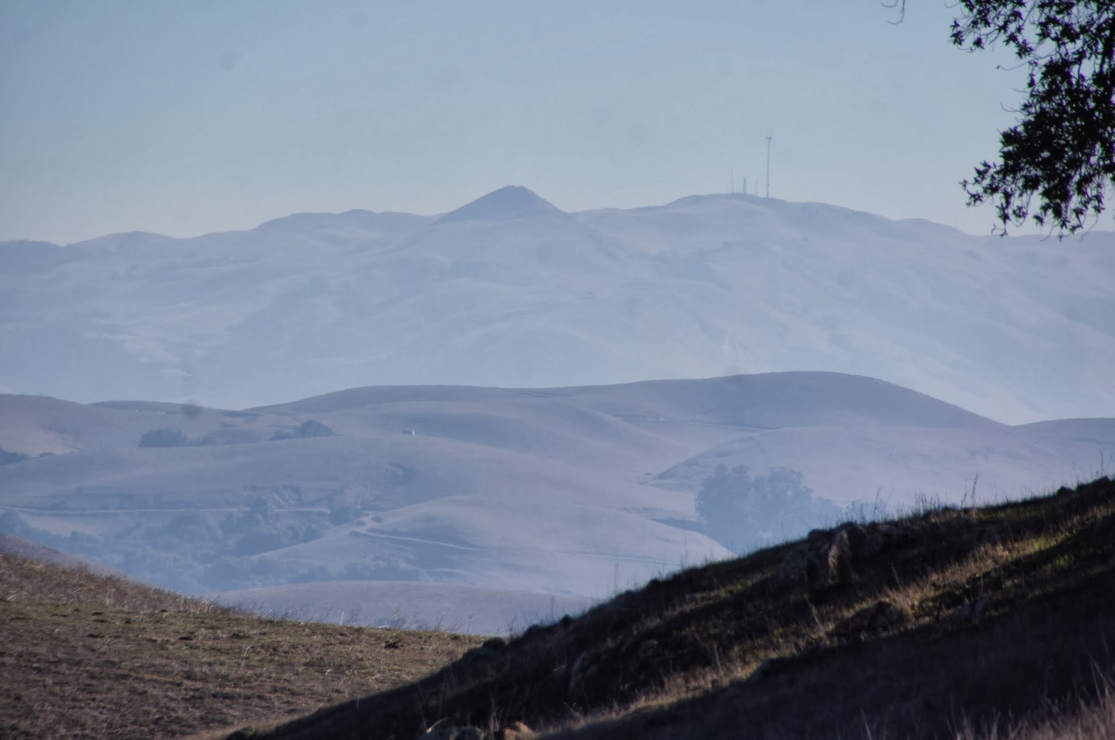
Vista Peak is a perfect name for the highest point of this trail. Standing up there (and also for a good part of the trail leading to it) one can see far and wide. Assuming the air is clear, of course. I aught to return to that place after it rains because on both days I was there the visibility was not great. Mission Peak appeared very hazy through the dirty air.
Mission Peak
At Vista Peak, a little off the trail, there is a small grove of low-hanging live oaks where I stopped for a short rest. When I returned there with the group 4 days later, the children had much fun playing under (and sometime on) these trees.
Coastal Live Oak
It is all downhill from that point :-)
The oaks on Vista Peak
The pretty views continue on the way down too. Like this moon over the hill:

Or a slanted tree, neatly trimmed by grazers:

And pretty birds on shrubs:

Yellow-rumped Warbler, 12/14/13, photo by Papa Quail


Western Bluebird

Black Phoebe, 12/14/13, photo by Papa Quail


I completed the loop and went down the trail toward the cattle gate. There was no trace of the bobcat, but my way was blocked by a pregnant cow who stared at me with hostility. Having faced a hostile cow in Sunol a few years ago, I didn't take any chances and made a large detour around the cow while constantly talking to her calmly and reassuringly.


I hiked this trail by myself on 12/10 and 4 days later I lead my chikas' 4H group there. Needless to say, the bobcat wan't waiting for us. Nonetheless, everyone had a great time, chidden and adults alike.