Date: August 5, 2016
Place: Mineral King, Sequoia National Park, Three Rivers, California
Coordinates: 36.497937, -118.615552
Length: 5 miles
Level: Strenuous
This is a post about the fifth and last day of my backpacking trip with my friend to Mineral King last August. To read about this trip from the start, here's
a link to the first day post.
On August 5 my friend and I woke up to the last day of our backpacking trip in the Mineral King area of Sequoia National Park. As in each of the previous mornings we got out of the tent before sunrise. The couple that camped at the prime location were already out and about. Everyone else who had arrived late on the evening before were sleeping still.
Sunrise wasn't any dramatic or spectacular as it was on our previous mornings. The dim light just grew slowly stronger and brighter until we could see sun spots on the forest floor. The water of Cliff Creek was bitterly cold. Much colder than any lake we've camped by so far. It was pretty shallow, too, and the flow was fast. I washed my hands and face but passed on a more thorough bath.
 |
| Sunrise at Cliff Creek |
We got organized silently and efficiently, but the best of our efforts were no match for the prime couple - they were already packed and ready to go when we had just sat for breakfast. They were on their way out as well. "See you at Mineral King," they had told us before departing, but we knew there was no chance in the world we could overtake them on the way out.
But the moment they vacated their prime location my friend suggested we'd go and have our breakfast there, and that's what we did. We ate slowly, looking over the rushing water, talking softly, not hurrying to leave.
 |
| View of Cliff Creek from "The Porch" at Cliff Creek Campground |
But we didn't want to delay too much. We still had a good hike ahead, and much of it uphill. We finished our breakfast and finished packing.
All of our neighbors were still in deep sleep when we were ready to go. I looked upon the tents and the hammock and wondered how many people could fit in to that small camping area at the Cliff Creek campsite. Being the first (or last) campsite for many backpackers in that area it was a heavily used spot. While the place itself was mostly clean and not too scarred, going in the bushes had sadly revealed that not everyone was following the "Pack it in -Pack it out" rule. Not when it came to toilet paper :-(
I didn't feel any particular attachment to that place, and no twitch of the heart when we finally took off.
Immediately we had to face our first obstacle - we needed to cross Cliff Creek. The river was shallow, but not enough, and it was flowing fast. A row of large stones has been laid across and we've seen the prime couple cross the river hopping on these stones. I didn't feel I could do that without getting my shoes soaked and I didn't feel like hiking all day with wet shoes. So I took my shoes off, rolled up my pants, and waded in the water.
I lost all sensation in my feet within seconds of stepping in the water, and a few long minutes to recover it after crossing and wearing my socks and hiking shoes back. All and all, it was after 9 am when we finally started our hike out of the Cliff Creek valley.
 |
| From (almost) Cliff Creek to Mineral King, over Timber Gap. Trail end is at the red mark (I turned my GPS on late and forgot to turn it off at the end) |
We were facing an uphill hike again, but we weren't concerned. I was facing a more daunting task - to stretch my camera battery life to last the day. Only a few minutes up the trail and the battery indicator dropped to one line - less than 1 fifth charge.
No problems, I thought to myself. What could we possibly see on the way out? At least on the first part of the ascend we didn't see much that was notable, and no wildflowers. It seemed that all the undergrowth plants had gone to fruit a while ago.
 |
| Gooseberry, Ribes sp. |
We were climbing up a narrow forest trail. The slope was steep, but the trail had switchbacks with long, low grade stretches. We walked in a slow but steady pace and didn't stop much for breathers. At least in this sense we did much better than on our first day, going up to Monarch Lake.After 4 days above 10,000 feet we were sufficiently acclimated.
I could hear birds in the trees, and even got to see a steller's jay. But the only evidence I have of their presence there is this photo of a feather that was lying near the trail.
 |
| Feather of a Steller's Jay |
We were going up higher and higher. Our trail was going along Timber Gap Creek, a tributary of Cliff Creek. We could tell there was water running down below but we couldn't see any of it, not that early in the hike.
Even bland then the slope became somewhat steeper and the trees opened up a bit so we got a view of the mountains to the north. I looked longingly at the bare granite peaks, knowing that they weren't really bare. That they held an ethereal beauty, observed only by those who would make the effort of walking up those sheer slopes.
These occasional openings also gave us a good view of the forest near us. It didn't reveal anything I didn't know but it was no less sad to see the casualties of the long California drought and the boring beetle attacks.
 |
| Casualties of the Drought |
The forest we were walking through was of mixed conifers, dominated by red fir and sugar pine. The cones of the sugar pine are quite impressive. There were many of them on the ground near the trail.
 |
| Sugar Pine Cone |
Little brown birds were hopping in the branches of a dead fir near the trail. With some patience I succeeded in getting a reasonable photo. The reddish dead needles aren't the best of backgrounds for the gray-crowned rosy finch.
 |
| Gray-crowned Rosy Finch |
After an hour of continuous ascend we came out of the woods into a clearing. The clearing wasn't clear at all, just of trees. a thicket of willows and other shrubs crowded a small brook that flowed through the clearing, running hastily to join the creek way down below. Crossing this clearing we had walked between two green walls of vegetation
 |
| Willow Pass |
We were walking high above the creek and for brief moments we could even see glimpses of the water below. I didn't dare approaching the edge as I didn't want to see that creek from too close. The shoulder of the hill was neatly landscaped, better than any human gardener can do. The most prominent color after green) being the fireweed purple.
 |
| Fireweed, Chamerion angustifolium |
My friend and I weren't the only being enjoying the wildflower display. Many insects hovered busily from flower to flower, foraging for sweetness.
 |
| Bee enjoying the fireweed |
At last the trail came close enough to the edge and we got a clear view of Timber Gap Creek. Not far downstream the water disappeared in the woods. Shortly after, so did we.
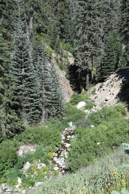 |
| Timber Gap Creek |
It was on this part of the trip that we finally made complete transition from spring to summer. There were a lot of wildflowers still, but many plants that I've seen blooming along Cliff Creek have gone to seeds on the sun-washed slope we were on.
 |
| Sierra Bog Orchid, (Platanthera dilatata), and Pacific Mountain Onion, (Allium validum) |
I didn't recognize all of them. Definitely not the composites, which I have hard time identifying even while blooming. It was tempting to blow their parachuted seeds into the air like I used to do as a child but I resisted the urge, letting Nature dictate the timing of seed dispersal.
 |
| Parachute seeds! |
As we were climbing higher our pace got slower and slower. We didn't take many breaks but we did ease the effort. We were coming to terms with the fact that this was our last day in the wilderness. My friend thought we might stay the night at the Cold Springs Campground at Mineral King and drive home on the morrow. I thought that if we'd made it out at a reasonable time we should drive all the way home. We had a bit of a discussion about what would be a reasonable time. I set my limit at 5 pm, arguing that if we'd leave later I would not have the energy to drive much that night. My friend doubted that we'd make it out by 5, but I was optimistic. This time I felt much more confident about what we could accomplish. At least based on how I was feeling.
But while still immersed in Nature, I tried making the best of it. Even of the tiniest bits of it.
 |
| A spider on a Ranger's Button (Sphenosciadium capitellatum) |
The trail went in and out of the woods in a steady, low-grade ascend. The day progressed from warm to hot and we were sweating and panting as we walked. We moved much slower now and took short breathers more frequently.
 |
| A 'Guardian of the Forest' (fake name I just made up), fungus. |
Every time we stepped out of the woods we found ourselves in a field of wildflowers. A couple of times we crossed little brooks that run down the mountainside to join with Timber Gap Creek. Each time my friend would bend down and wash her face in the fresh creek water while I admired the wildflowers.
 |
| Columbian monkshood, Aconitum columbianum |
Many of the plants have already finished blooming but their fruit were just as beautiful, like elaborate ornaments.
 |
| Twin Berry, Lonicera involucrata |
One time we stepped out of the woods not into a wildflower field but onto a dry, rocky clearing. From there we could see the opposite range an the north and realized we were quite high already. We were nearing the gap.
We stayed there only for a short while. I wanted to make it all the way to Timber Gap before stopping for lunch, but we did have a short snack break, and to stretch our limbs.
And to admire the trees, of course.
 |
| California Red Fir, Abies magnifica |
After that clearing the trail became steeper. We couldn't see the top of our ascend but upon consulting the map I figured it wasn't much further up. The forest thinned out and the undergrowth vegetation was thicker and greener.
Fallen trees created clearings too, also making room for new saplings to grow up.
 |
| Decomposition |
Two backpackers, a father and a son, came down the trail and stopped to have a shot chat with us. we welcomed the break and the assurance that the gap wasn't all that far away. Half a mile, maybe, the older man told us.
After they moved on my friend noted that they were the first people we had met that day since early morning. I thought that was very odd, considering that it was Friday. I had expected many more backpackers to go into the wilderness for the weekend.
 |
| Brewer's Fleabane, Erigeron breweri |
We were walking close to the creek now. It was still quite far below but the trail came close to the drop.
A light brown blob in the grass caught my eye and I moved the vegetation with my pole, uncovering a huge mushroom.
We kept going on. I half expected to see the gap around each turn of the trail but we weren't quite here yet.
 |
| Coulter's Daisy, Erigeron coulteri |
We crossed another tributary. According to the map we were to cross it again a bit further up the trail. I was glad to see the creek because it was a good marker of our location. I was less pleased to realize that we still had quite a way to go - we weren't as close to the gap as I had thought based on the other backpackers' words.
 |
| Double Honeysuckle, Lonicera conjugialis |
We were now walking along the border of the forest, enjoying alternations of sun and shade. It was past mid-day but the sun was high and there was no wind. I felt the sweat running down my shirt.
The narrow dale
And then we were right on top of the creek again, and now the creek was not so far below. It was also very narrow and was flowing a trickle. We were approaching the source.
 |
| Timber Gap Creek |
Another turn of the trail and I stood in my place, gasping, because I was beholding the most amazing beauty, the most wonderful spot along that day's trail. I was standing before a wide and open mountain dale glistening in bright sunlight and displaying the most intense bloom I've seen on the whole trek. All colors were represented there. So many wildflowers that my head was spinning. And scores of butterflies were fluttering over the flowers.
My friend came up from behind wearing a huge smile. She, too, was uplifted by the wonderful sight.
I stepped further around the curve, raised my camera, clicked and ... yok. It was there, at this most spectacular place that my camera battery finally exhausted. No more juice left for even a single shot more.
As if to taunt me, at that moment a pair of sooty grouse stepped onto the trail and stood there for a few long seconds while I tried frantically to squeeze another shot from my dead camera, to no avail.
The grouse eventually slipped into the vegetation. I think I might have emitted a swear word at that point, the only time in the entire trip.
I was glad my friend didn't say anything, although I could guess what she was thinking. With a sigh I took my backpack off and tucked the now useless camera in it. At least it would not burden my neck any more.
I pulled out my phone and turned it on, setting it for the energy-saving flight mode. There was no hope now of getting any decent close up of the flowers, or of anything.
But I could at least get some passable images of the places we walked through after that. Including that amazing bloom field. So all the photos from now to the end of this post were taken with my phone, pardon the poor quality.
 |
| Up near Timber Gap |
Then we crossed the creek one last time, and where we had crossed it it was already dry as a bone. All the water running in it came from springs that were now below us.
 |
| Timber Gap Creek, the dry beginning |
Eventually we plunged into the forest again and walked the last quarter of a mile in the thin shade of large, healthy pines and firs that were far enough apart to let considerable sunlight through. the undergrowth there, however, was thin and grayish, and not all too inspiring - there was shortage of moisture there, no doubt.
My friend was slowing down. She was hungry and had pain in her knees. I left her lagging behind and sprung forward, sensing that the top is right around the next switchback.
And just like that, I was there. I walked into a wide, flat clearing between some large red fir trees that looked like an ancient pagan worship place. I dropped my back pack to the ground, threw my arms in the air and screamed at the top of my lungs. Then I run back to the trail and called to my friend to come up. That finally, we were at the gap.
 |
| Timber Gap |
We had a really long break there. We rested, ate, and chatted. We also explored a little, checking out the view, the clearing, where there obvious signs of people previously camping there, and even lighting a fire although forbidden at that place, and most sadly - inscriptions on the tree trunks. I don't know how is it that some people feel the need to vandalize nature's beauty. In my opinion it is sacrilege.
After that long break we got up to go down. For some time we were walking in a relatively dense forest where I took no photos. Then, after about half a mile, we broke through the trees into the open, and the beautiful and familiar valley of Mineral King was before us.
 |
| Mineral King basin |
We had a long way down still, but our pace was quicker. We went down open slopes coated with fragrant Artemisia and crossed through small groves of pine and fir.
Every now and then we crossed paths with hikers that were going up yet, even this late in the afternoon. We were now inside the radius of day hikers.
Down and down and down we went, and my body started rebelling. I had pain in my knees, pain in my crotch, and sore spots on my feet. But the worse was yet to come - as I went down the soles of my feet started flaring up in pain. Soon i felt like I was walking on hot coals.
My friend wasn't doing much better. Her back and knees were hurting and she had slowed down considerably.
I slowed my pace, trying to match my friend's, but my feet were burning whether I walked or stood still, and I was eager to get down and take my shoes off. I had my phone in my hand and tried to document as much of the beauty I saw around me, to distract my mind from the pain.
Finally we came upon the trail intersection where five days before, on our first day of the trip, we had decided to go up to the Sawtooth Pass.
There was no more debate as we made the right turn to the final, half-mile trail down to the parking lot.
The last stretch was the most painful. I nearly run downhill, yearning to get to the car and relieve my poor feet from the shoes. My friend, on the other hand, was taking baby steps, easing the descent as much as she could on her sore knees.
 |
| Mineral King Valley, view west |
The first thing I did when I got to the car was to drop my backpack to the ground. Then I pulled the tarp it was wrapped in and got my sandals out of the trunk. Then I sat on the ground and took my shoes off. I feared to see what my feet had turned into but to my surprise, other than a few spots where I could see a blister forming, my feet looked quite normal. The burning sensation was alleviated and I put on my sandals and finished unwrapping my car. I then went to the bear box where we had stashed our excess food before going on the trek and got everything back in the car. It was then that my friend finally arrived. She let her pack drop down and went to the pay phone that was in the parking lot to call her family and inform them that she was still intact and hadn't been consumed by bears.
We didn't really discuss what's next - we were both weary and ready to get home as soon as possible. So we finished arranging everything in the car and then said goodbye to the realm of beauty and freedom that was our world in the past five days and then embarked on the long drive down the mountain and back to the Bay Area.
It was my third time in Mineral King and my second backpacking trip there, and as I was driving away I was already musing about when i should go there next and which trail should I take. My friend didn't comment on that. For her it was the first time there, and very likely the last time too, as she and her family were about to move out of California this fall. For both of us, each with her own reasons, this trip has been an essential getaway, a transition into a world of peace, incredible beauty, and complete freedom. It was the greatest balm to all of our spirits' sores.
It was well after midnight when I dropped my friend at her house and made it to my home. I sneaked quietly into the house trying not to wake anyone up. Those were my last quiet moments in the month of August. On that morning I would wake up to a full house and on the following day embark once more on a trip to the Sierra Nevada, this time with my entire family including Grandma Quail and Pappa Quail's nieces. A busy trip that had started at the
Calaveras Big Trees and ended at the
Devil's Postpile National Monument. A trip in which I would cover much more ground but walk much less and lose all of the peace of mind I had found at the peaks of Mineral King.
Many thanks to members of the California Native Plants Society for their help in identifying plants!


