Tuesday, April 11, 2017

The Narrows of Marble Canyon

3rd Narrows of Marble Canyon

Date: November 25, 2016
Place: Marble Canyon, Death Valley National Park, California
Coordinates: 36.619184, -117.330605
Length: 4.8 miles
Level: moderate
A 4x4 vehicle is required to get to the trailhead.

The morning of Thanksgiving Day 2016 in Death Valley NP was clear and very, very cold. Pappa Quail was the first to stick his nose outside of the tent, and by the time I got out he had the campfire going and the water fro the morning tea boiling. Such a treat!
He had also found the dutch oven under the table where I had left it the night before and had sampled its contents - my pitiful first attempt at a campfire peach cobbler. He managed to scrap some unburnt bits and actually liked it! (Or perhaps told me he did to make me feel better.)

By the time the chikas were out and we all finished breakfast the sun popped from behind the mountains and the morning chill had subsided. We got ready for the day's planned hike.
Our original plan was to meet with friends there, but their plans have changed, and so we were in Death Valley by ourselves, having already seen all the 'must see' park sites, and with a 4X4 vehicle on hand.

We knew this a couple of days before arriving at Death Valley, so when Pappa Quail asked me where are we going to hike I had the trail already selected and ready.
"It'll take us 2 hours to get there," he observed after one glance at the map.
The way to Marble Canyon, a look back toward Amaragosa Range. 
And he was right. The road, if it can be called that way, was a dirt road that begun in deep sand area behind Stovepipe Wells air strip, and continued as a very bumpy gravel road. It goes through a narrow canyon area and then splits - left to Cottonwood Canyon Rd and right to Marble Canyon Road. We continued left and there we really had to make good use of that 4X4 because the 'road' condition turned from bad to worse. Occasionally we had to stop, and one would go outside and direct the driver around rocky obstacles or gullies too deep.

W found a reasonable flat patch by the side of the 'road', parked the car and started to the mouth of Marble Canyon. Right away I realized that my assumption that in fall time there won't be any bloom there was wrong. It wasn't a spread by any means, certainly not like in spring earlier that year, but we did encounter some blooming plants along that trail. The first of which I almost stepped on. I probably would have if not for its flowers- the foliage blends in so well with the gravel.
Velvet Turtleback, Psathyrotes ramosissima 
Whenever there are flowers one might expect butterflies. I guess that applies to the deep desert as well. We did see only that single butterfly on the hike, and even that one was sluggish. 
Painted Lady
Even before arriving the canyon mouth I could tell why it was called Marble Canyon. The gravel of the creek bed was dotted with marble bits. I'd say pebbles if they'd been more rounded. My elder chika got really fascinated with the marble and soon her pockets were full of little shiny white pebbles. Ofter some gentle prodding from my she turned her pockets out and let her little treasure drop back where it belonged.
Marble Pebble
The complete hike is a twenty-some miles loop encompassing both Marble Canyon and Cottonwood Canyon, and is usually done in a two days backpacking hike. We had no plans to backpack that trail (although we might in some future time). All we did was to walk up the canyon as far as time would allow, then turn around and walk back the same way.
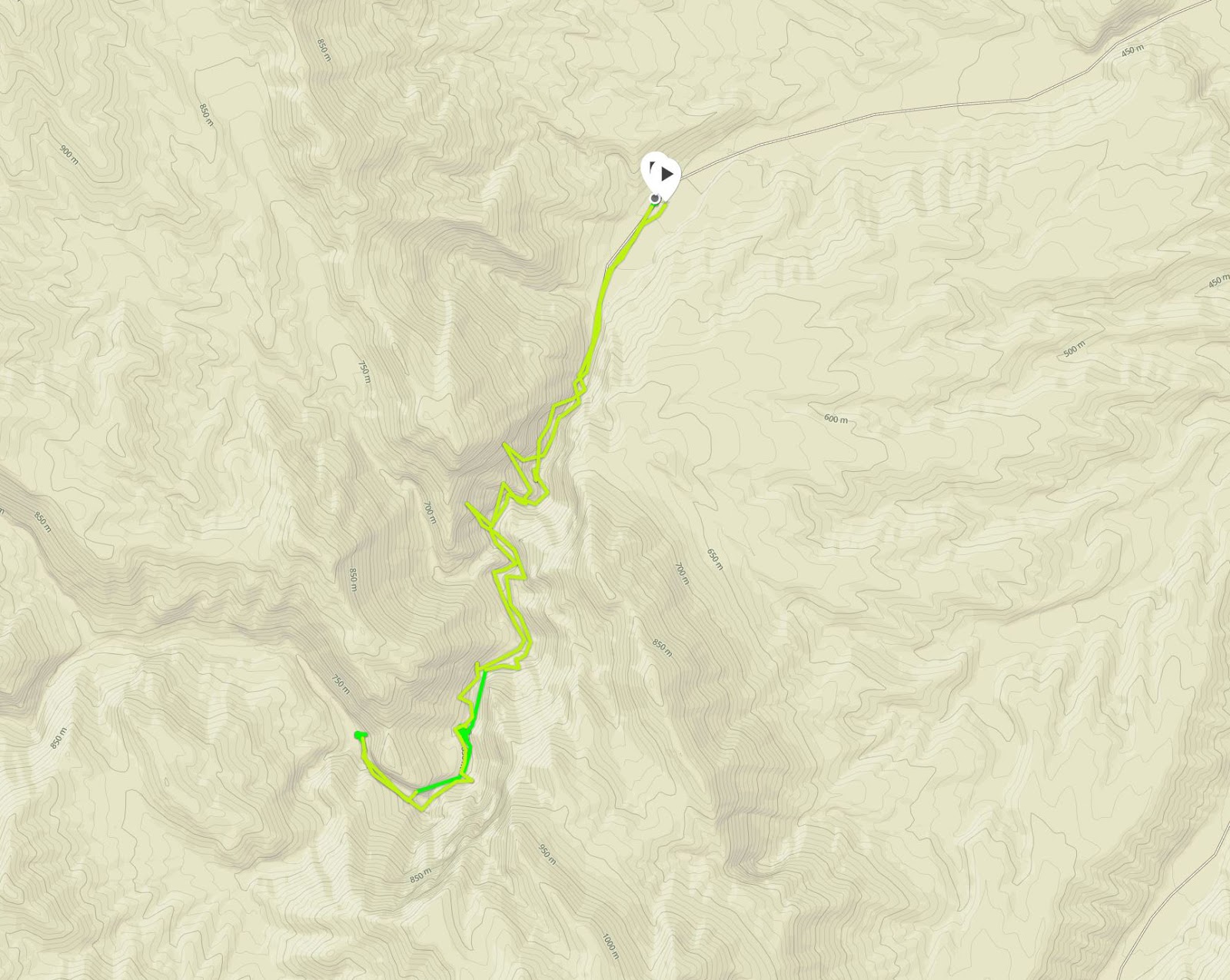
Our hike up and down Marble Canyon as captured by Pappa Quail's GPS
When we arrived at the first narrows of the canyon we saw a small parking area with a few parked cars. Apparently we could have continued with our car a bit further. In addition, some of these cars were regular 2WD family cars, which have traveled the access road without any breakdown. Moreover, and what I couldn't understand - a couple of these cars looked shiny and spotless without a speck of dust on them. I had to conclude that these cars had levitated all the way to the trailhead...
Either way, I expected that we would not be alone on the trail.
A few steps past the trailhead
The canyon walls closed in on us even before we reached the parked cars. We passed them quickly enough, nodding briefly to a woman who was hanging near her open car, tending her dogs. I stopped the chikas from approaching the dogs and their owner as they looked dusty and fatigued like they had just finished their hike.
I diverted the girls' attention to the beautiful geological display of the canyon walls.
Layered sedimentary rock cliff near the trailhead. 
One of the things I like in the desert is the visible geology in all of its awe-striking beauty. But the rocks were not completely naked - there were plants growing in the cracks and in corners where enough soil had settled. 
Pygmycedar, Peucephyllum schottii
The plants growing on the rock walls are quite hardy - they don't get as much water as those growing on or close to the wash bed. Many of the plants we saw were dry. Some of them of course, were annuals that had completed their life cycle and set their seeds.

Fairly close still to the trailhead we found a burrow in the rock. I wonder wether it was the remains of a futile mining effort or a primitive residence of some desert hermit.

The trail description I had listed four 'narrows' - sections of the wash where the canyon walls are tall and sheer and very close to each other. The higher the canyon walls and the narrower the passage between them - the more exciting the hike is. The type of rock combined with the space and violent nature of precipitation and collection leads to more of these 'narrows' or slot canyons seen in the desert.
Marble Canyon
The sun shines between the narrow canyon walls only a part of the day. A small part, late in November.

The variety and beauty of the rock formations blew my mind. I kept seeing shapes and little fantasy omens in the cracklines and color patterns. Little messages from the universe emulated in the rocky images.
Angel
Turtle


Here are some of the interesting formations shapes I saw embedded in the marble walls of the canyon.


Flying Saucer


Bullseye

It is in these places that I feel most regretful for not taking the geology program in college. Its one of the first education gaps I intend to fill as soon as I find the time for it.


I tired to get the chikas' interest in these shapes but it took only a few seconds before they started naming imagery of offensive nature, so I shooed them off and sent them to follow their father up the canyon.


The narrows sections were spaced by more open areas of the canyon. In these places we stopped for short snack breaks and to enjoy the warm sunshine.
Marble Canyon
After the second narrows we arrived at what appeared to be a dead end: a huge boulder was blocking the canyon with now easy climbing over it.

We backtracked a few yards and saw that there was a line of rocks laid across the creek bed and a narrow foot path leading up the side slope to the right.
We sat there to rest a but, and as we were discussing what's next, a person came down that path. He was a sole backpacker who was coming down from Upper Marble Canyon, completing the Cottonwood-Marble Canyons Loop. He confirmed to us that the little foot path was indeed a bypass of the boulder block and that the Marble Canyon Trail continued further on past it.
Bypassing the boulder block
We thanked the lonely backpacker (how lucky is was that we crossed paths just at that moment!) and went on up the slope. After passing the boulder the trail descended back into the canyon. Shortly after we reached the third, and the narrows yer, narrows.

It is important to check the weather before entering a canyon narrows, for if a flash flood is a possibility it could be a dangerous trap. There was no such threat during our visit and we could enjoy the fun of Nature's rock trenches in all their glory.
Marble Canyon third narrows
I never fail to be amazed by plants who establish themselves on sheer walls. They are a weathering power to be reckoned with!
And they're beautiful.
Rock Nettle, Eucnide urens

We didn't get to the forth narrows of Marble Canyon. At the end of the third Pappa Quail announced that it was time to turn and head back, "if we're to drive out while there's still daylight." Considering the road's condition I reserved my usual protest and agreed.
On the way back through the third narrows I paid closer attention to the wall paintings. All natural, of course.


I cannot imagine the kinds of geological forces that produce patters like the one below. It looks more exquisite than any human-made art displayed in museums.


I also looked more carefully at the local flora. Some of the shrubs that at first glance appeared to be devoid of bloom actually did bear some flowers. Tiny flowers. And very few.


Brownplume, Stephanomeria pauciflora
In some cases the entire shrub was tiny. I almost stepped on this one that blended so well with the gravel of the creek bed.
Buckwheat, Eriogonum sp. 
As we walked down the canyon we could appreciate again how narrow the narrows really were. I wouldn't want to be between these walls when it rained on those mountains.

Now we were chasing the sunshine. We were less than four weeks before the winter solstice, deep in a canyon on the mountain range's eastern slopes, and daylight was waning fast. The higher regions of the canyon wall were still nicely illuminated though, and the reddish barrel cacti glistened in the light.
Cottontop Cactus, Echinocactus polycephalus
In the open sections between the narrows the sun reined still and we enjoyed the sweet afternoon warmth.

But as we progressed towards the canyon mouth these sunny areas were harder to catch. The sunny spots were receding faster than we walked.
Creek Bed Sediments 
The last walk through the first narrows was in complete shade. It was also getting colder.

Pappa Quail and the chikas walked quickly ahead of me. The chikas forgot their marble search but I kept looking for interesting rock patterns. This one below looks just like a liquid that solidified in mid-flow. It is, however, not an igneous rock but sedimentary, so I can't even guess how this pattern came to be.
Rock pattern
We saw a bit more bloom on our way and for once I was thankful for the shade because my photos of this plant from our way up the canyon while it was still in the sun came out too bright. The images look way better taken in the pre- twilight hour.
Fremont's Chaffbush, Amphipappus fremontii
The chikas called me. They had found a dead tarantula. Or at least one playing dead, because when I tried to move the 'corpse' with a stick to get it in a more photogenic position it started waving its hairy legs at me. Maybe it was just too cold. I snapped a few shots and we moved on, as we were getting cold too.
Tarantula
No doubt the best water in the area is found under the gravel of the creek bed. Enough for the desert holly, that seems to blend perfectly in the gravelly background.
Desert Holly, Atriplex hymenelytra
Probably the most dominant plant in Death Valley NP is the Creosote. It wasn't all that common up the canyon, but there were a few here and there. As I often see them, they bore the large brown galls like oddly-positioned fruit (they aren't fruit but insect-caused growths where the insect' larvae grow).
Creosote Gall
As we were nearing the trailhead I caught a glimpse of Dry Peak glowing in the sunlight high above the canyon. I looked at my phone - it was barely past 3 pm. Sunset was to be around 5 but on Marble Canyon it had already set.

There was no more color in any of my photos near the end of the hike. The sky above was bright blue still, but down below it was twilight. Has we been backpacking our day would have been called then and there.

As it was, we still had a couple of hours drive to get to Mesquite Springs Campground. We arrived at the car and were on our way out without delay.

It was only after we cleared the Panamint Range that I stopped the car and stepped outside to take one last shot of the range to the east as it glowed in the light of the broader world's sunset.


That night was even colder than the night before, and much windier. Well practiced, we got dinner down and chikas in the tent before 8. Once again I remained outside to clean up and enjoy the peace. There were no stars to see that night for the clouds had rolled in.
I didn't stay out very long. The wind had intensified and I drowned the campfire in fear of flying  embers. Once the fire was quenched it was bitterly cold out so I joined my family in the tent for our last night in Death Valley.

Many thanks to members of the California Native Plants Society for their help in identifying plants!


Thursday, March 30, 2017

Exploring New Sand at the Eureka Dunes

Eureka Dunes


Date: November 24, 2016
Place: Eureka Dunes, Death Valley National Park
Coordinates: 37.11377, -117.68100

Distance: 0.7 miles
Level: Strenuous

After the disaster that met Pappa Quail's camera at the Mormon Rocks we needed to get a new one. We were very fortunate to find a store that was still open in Phelan so late in the day. They only had a lens replacement, however, so I suggested to get a cheap and simple 'Point n' Shoot' pocket camera for the broad angle shots. In the end we bought the replacement zoom lens and Pappa Quail attached it to my camera, and I used the simple pocket camera for the remaining days of our road trip.
It turned out a very useful arrangement: the pocket camera yielded quite decent quality photos. Not up to notch like the one I lended Pappa Quail, but on the other hand it was much lighter and quicker, and I was not as stressed about it banging against rocks.
We managed to get to Ridgecrest that evening and had passed the night in a hotel there, and first thing in the morning we were headed toward Death Valley National Park. Sacrificing that day's hiking time, we made it right away to Mesquite Springs campground to find a spot. Mesquite Springs is a lovely, and quite desolate campground. It is the first campground we've ever camped at in Death Valley NP, when still a young couple sans chikas. It is a non-reservable campground, and it being Thanksgiving time, I was worried about not finding a place and having to camp in the wilderness. (Not that I mind wilderness camping, but on this occasion we preferred having the usual comforts of an established campground).
We were right to hurry to the campground. There were only 4 sites available when we arrived and by the time our tent was pitched the campground was full. When we were done setting camp and eating lunch, however, is was already afternoon and the day was growing short.
Pappa Quail gulped when I told him I wanted to go see the Eureka Dunes. Apparently, the dunes nearly two hours drive away from our campground. We went anyway, willing to drive back in darkness.
The Eureka Dunes are located in the south corner of Eureka Valley in the northwest part of Death Valley NP. To get there from the main park area where we needed to drive north on Death Valley Road, a long dirt road that leads to the north tip of the park and passes the Last Chance mountain range westward, leading out of the park toward the town of Big Pine.

Endless dirt road northward. 
It was a very lonely drive. We saw one car parked on the side of the road and along our drive we passed maybe two other cars. These were all who ventured north of the main park region.
The road splits at the Crankshaft Intersection and we stopped there momentarily before taking the Death Valley Road northwest toward Big Pine. I had to take in the scenery there. The vastness of the desert, the raw power of the sharp-angled mountains, near naked of vegetation.
I also had to photograph the interesting display at the intersection.  All made of ... crankshafts.


We continued across the Last Chance mountain range and past a small gold mine, abandoned of course. We descended into Eureka Valley and the road was straight and level once more. Just before exiting the park we took a left (southward) turn to the dunes.
The Eureka Dunes, the tallest sand dunes in California, were quite visible from the Death Valley Rd, about 10 miles away.
Eureka Valley and Dunes. 
Pappa Quail was driving and I was hungrily swallowing the view. Every now and then I asked him to stop so I could step out of the car and snap a few shots. All of these mountains deserve having their image displayed. I chose this one below.
"Last Chance" 
The mountains tower over the Eureka Dunes, dwarfing them. It was only when we approached that we understood how large they truly are.
Eureka Dunes
There's a small, primitive, and very run down campground at the foot of the dunes. I had this campground in my mind as a backup in case we couldn't find space at Mesquite Springs. When we arrived there, however, I was thankful for not having to stay there. I would have loved the isolation of the place, but everything else about this campground depressed me, as its few amenities were broken and soiled, the ground littered, and the single stall pit toilet in a disgusting state. It's unlock able door bore an angry note of a park ranger fuming over campers dumping trash into the toilet pit (a big no-no. Don't ever do that). In short, I'd rather have gone wilderness camping if that was the only established option.
A creosote (Larrea tridentata) bush at the dune's foot. 
The few campsites appeared occupied. Other cars were parked together a bit further away. We left the car near the campground and started toward the dunes. We had arrived there too late to make it to the summit, but still had a good hour of daylight to explore the dunes.
Our hike as captured by Pappa Quail's GPS
Going up a tall sand dune isn't easy. For each two steps you take, you sink one back. We found the tracks of previous hikers and followed in their footsteps, using their deep footprints as 'steps'. Still, it was a slow work uphill.
Going up
Taking frequent breathers along the way I stopped and looked around. One of the things I like about the desert is the visible geology, naked and unhidden beneath alluvial soil and vegetation.
Last Chance
The Last Chance mountains are of sedimentary rocks, limestone and geological relatives. The colorful rock layers marked the eras in which this place was submerged under water. Now one of the driest places in California, it is hard to believe this place was ever submerged.
I caught up with Pappa Quail and asked him to take a zoomed-in photo of the rock layers.
Last Chance - zoomed
An expert geologist may be able to count the number of geological eras by the visible rock layers, as a dendrologist counts tree rings. I am expert on neither so I just enjoyed the view east and then turned my gaze to the north. 
There, below me, lay the vast Eureka Valley, flat and arid. A white evaporation flat stretched to the west and a small column of dust marked the progress of a sole car in the distance. 
Eureka Valley
We continued along the dune's ridgeline. The wind was picking up and a sheet of sand flowed over the dune face. On the lee side the sand was settled in ripples, some ridged with dark grains. more dark sand had 'puddled' at he bottom of the concave vales between the dune ridges. Everything was on the move.
Ripples
We arrived at the summit of the first dune and the chikas decided they'd had enough and wanted to stay there and play in the sand. Pappa Quail remained with them while I went forward a little bit further. There was no going to the highest peak that day, but I did want to get a bit wider view.
Eureka Dunes
Eventually I too had to turn around and go back. I said goodbye to the high dunes, silently promising to make better timing plans for my next visit there. 
Ridgeline
On my way back I witnessed the first sunset. I stood at the perfect spot to see the sun disappear behind the peak of a nearby dune. 
First Sunset
A few steps away, however, and I was back in the realm of daytime, if only for a short while.
Creeping darkness
From there on I was hopping between night and day as I made my way back to my family and down the dune.
And with each step night was gaining.
Night and Day
And then the sun disappeared completely, this time behind the Inyo Mountains on the west.
There was still enough light to make it back to the car. And also to photograph some more. It turned out that my simple pocket camera had good light sensitivity.
I balanced on the ridge of the dune and progressed forward in large hops. Occasionally I looked down - it was a steep slope, and being made of sand - a very inviting slope. It was not in my desired direction, though.
Slide
After reuniting with my family we split again - Pappa Quail and the chikas took the shortcut down to the campground: the chikas rolled and Pappa Quail run down the slope. I waited behind for some time, unwilling to leave this place, but eventually I too started down the steep slope.
Last Sun
I tried butt-sliding, and failed miserably. Sand isn't snow - it is sticky. I had to paddle with my hands and feet to make it down a grade I would have had zoomed through if it was snow-covered.
But the slow, hard-working descent had its bonuses, because I had the time to stop and look at the pale plants that grew at the lower part of the slope. One of them was this interesting shrub:
Desert Dicoria, Dicoria canescens

The further down I went, the further the rest of my family got. I stopped to look at this strange-looking grass that turned out to be quite rare and endemic to the Eureka Dunes area and when I raised my eyes from the plant I saw that Pappa Quail and the chika were already near the car.
Eureka Dunegrass, Swallenia alexandrae
The post sunset daylight was disappearing fast. These last images only look bright because of the camera's sensor adjustment, but in fact these photos were taken under low light conditions. Including this beetle that crossed my path to the car.

The wind was blowing hard now, and when I made it back to the Eureka Dunes Campground the chikas and their father were already tucked inside the car, safe from the grind of the airborne sand. I took one last snapshot of the Last Chance Range in the last of that day's light and got in the car.
Last Chance in the last light
It was a very dark drive back to Mesquite Springs Campground, and very windy and cold when we got out of the car. Without delay we built a campfire and cooked dinner, after which the chikas and Pappa Quail went inside the tent.
I remained outside to clean up and enjoy the desert silence. I also had a little surprise to prepare. Just before going on this road trip I invested in my very first dutch oven and I wished to surprise my family with a campfire peach cobbler in the morning.
I mixed the ingredients and tried my best to maneuver the heavy iron pot on the glowing coals. Then I sat back and looked at the heavens.
It was a no moon night and as I had hoped for - clear skies with a spread of stars that can no longer be seen anywhere near the Bay Area. It was absolutely spectacular.
I felt the urge to document the starry night, but sadly, I have not the proper equipment for night photography. I switched the lenses on my old camera to the wide angle, and went for a walk around the campground. But even the more sophisticated camera didn't work. After much manipulations and frustration I managed to snap a single shot, then gave up and resumed my quiet enjoyment to the scenery without worrying about documenting it.
Eventually I got too cold and tiered. I walked back to the campsite and put the camera away. Then I checked the cobbler: it was almost completely burnt. With a sigh I removed the dutch oven from the campfire leftovers and set it under the table, hoping that no local animal would prove strong enough to lift the pot's heavy iron lid. Finally, I quenched the fire and went in the tent.
Orion's Belt
I have previously visited three of California's inland sand dunes. The vast Imperial, Algodones Dunes, the popular Mesquite Dunes, and the Mojave Preserve Kelso Dunes, which are the only dunes I have actually submitted (twice). Now I have been to the Eureka Dunes as well, and I would go back there in the future to summit this 680 ft sandhill. I will try to time my next visit with the desert spring bloom, because the Eureka Dunes have some of the most unique and interesting flora of California.


Many thanks to members of the California Native Plants Society for their help in identifying plants!