 |
| Mount Diablo Globe Lily |
Date: May 24, 2020
Place: Mount Diablo State Park, Danville, California
Coordinates: 37.844214, -121.949251
Length: 12.5 miles
Level: Strenuous
Frustrated by the cancellation of our long weekend camping plans and by the difficulty of prompting my family to go on day hikes I decided to go on my own. Having hiked the east side of Mt. Diablo State Park on the day before at
the Old Finley Rd area, reminded me that I've been wanting to hike the Summit Trail for a long while now. Now I had the perfect opportunity, so I took it.
Still under Shelter-in-Place orders, the park was closed to motor vehicles and the nearest parking place was almost a mile away from the South Gate entrance. Committed to my plan I parked and got out of the car, and immediately I ducked back inside to grab an extra water bottle - it was a hot day outside.
The walk up the road to the park's entrance was full of bicycle riders on their way in or out of the park. All of them were wearing big smiles - a biking time with no cars to worry about!
At the park's gate stood a sole ranger wearing a mask. He was having a deep conversation with one of the cyclists. I extended my hiking poles, turned my navigator on to record my hike and started hiking the Summit Trail.
 |
| My hike as captured by my GPS |
Summit Trail: South Gate to Live Oak Campground
At the bottom, the Summit Trail doesn't follow the South Gate Road but heads straight north along the contour of the mountainside, not gaining much altitude. The scenery was that of an open oak savannah and the grass was already dry and yellow. The thin oaks cast very little shade on the trail but although it was hot, I didn't need much shade yet.
 |
| The Summit Trail, |
The dry grass didn't seem promising in terms of wildflowers but soon enough I began to see patches of blooming clarkia.
 |
| Woodland Clarkia, Clarkia unguiculata |
About a third of a mile into the trail the scenery changed from oak savannah to a low chaparral. Much of that chaparral included poison oak so I had to take care to stay at the trail center. This became somewhat challenging whenever I encountered other trail users. Other hikers would sometime squeeze to allow me to pass, but there were also bikers who would come charging around the curve making me to squeeze myself to the vegetation. It wasn't coronavirus I feared on those occasions but being driven off the trail.
 |
| Summit Trail |
The trail took a narrow concave curve through through a small, nameless dry creek. A small grove of buckeye trees were growing there, all in full bloom. I love the chandelier appearance of the blooming buckeye this time of year.
 |
| California Buckeye, Aesculus californica |
A pink spot near the ground caught my eye. I stopped to look and gasped with surprise - it was a mariposa lily of a species I've never seen before. There were two flowers only, the only two of that species I've seen the entire hike. I was very excited.
 |
| Splendid Mariposa Lily, Calochortus splendens |
Shortly after I had another surprise. Not as exciting, but interesting nonetheless. It was a single plant of the scarlet pimpernel in blue form. The scarlet pimpernel is not a California native plant and is very common now in disrupted areas around the Bay Area. I only see the orange form of this species here, whereas the blue form is more common in the east mediterranean region. It's the first blue scarlet pimpernel I've seen in California.
 |
| Scarlet Pimpernel, Lysimachia arvensis |
I passed another area of oak savannah. Here the dry grass was dotted with harvest brodiaea flowers, similar to those I've seen the day before on the east side of the park.
 |
| Harvest Brodiaea, Brodiaea elegans |
The sunlight filtered through the thin canopies, and the spider webs glistened in the patchy light. Most of the spiders I've seen along the trail had dome-shaped webs hanging from the vegetation about knee-high. Nearly all of them skedaddled down and away when I approached. Some stayed put but shook their webs in response to my presence, making it very difficult to focus my camera on them.
 |
| Long-legged Orbweaver |
I let the spiders be and returned my attention to the wildflowers. There were more of then now, in the somewhat less dry undergrowth.
 |
| False Babystars, Leptosiphon androsaceus |
The bottom part of the Summit Trail terminates at a deep ravine (no water was flowing there at the time). A small plank bridge stretched across the ravine and after crossing it I connected with the Dan Cook Trail (which is a continuation of the Summit Trail). This trail is a wide dirt road, and the photo below is really not a good representation of it because there were many people using it at the time, both hikers and bikers, many wearing masks and all practicing good distancing from one another.
Ignoring the mountain's contours, this trail slopes directly uphill, with very few curves.
 |
| Dan Cook Trail |
To my great relief soon after I begun ascending this trail I entered a forested area and was walking under a much needed shade.
 |
| Dan Cook Trail |
It was a hot day and it was getting hotter yet, and I felt the need to pause often to catch my breath and drink some water. On one of these pauses I sensed someone looking at me ... sure enough, an a nearby rock perched a lizard, eying me carefully.
The trail curved eastward and continued uphill at a high grade. I was now hiking the north-facing slope and there I was seeing mush denser vegetation and many more wildflowers. Some of these wildflowers, like the Chinese Houses, I have seen the day before on the east side of the park.
 |
| Chinese Houses, Collinsia heterophylla |
About mid-way up the Dan Cook Trail I saw the Mount Diablo Globe Lily and I stopped in my tracks. This is an endemic species, blooming only on Mount Diablo and the close vicinity. Every May I go hiking at the
Mitchell Canyon trail of this park to see these beauties in bloom, and this year it didn't happen because of COVID-19. I was hoping to see them on my family hike at
the park's east side the day before but didn't see any. Now here it was, blooming in all its glory, right there by the Summit Trail!
 |
| Mt. Diablo Globe Lily/fairy lantern, Calochortus pulchellus |
I kept seeing these fairy lanterns in patches along the Summit Trail up to fairly high elevation. Seeing them thrilled me. I didn't miss out on them after all!
Not to say that I was disappointed in seeing any other wildflowers along that trail, of course.
 |
| Indian Paintbrush, Castilleja affinis |
Summit Trail: Live Oak Campground to Summit Road Junction
I arrived at the Live Oak campground. It was from this area that I started my ascend the first time I summited Mount Diablo, nearly 20 years ago, with Pappa Quail and a friend.
Entering the campground I immediately recognized the third mariposa lily of the day - the yellow mariposa lily. There was a fairly large patch of them near the big rock where the trail connected with the campground area. This was getting to be a very exciting hike!
 |
| Yellow Mariposa Lily, Calochortus luteus |
I sat down at one of the empty campsites to rest and hydrate, and to appreciate the other wildflowers in this site, including the common ones. There were much fewer people walking the trail there. I looked absentmindedly at two young men that came up the Dan Cook Trail, passed me, and moved on up the continuation of the Summit Trail. I remembered them passing me earlier on the Dan Cook Trail and wondered when did I pass them.
 |
| Blue Dicks, Dichelostemma capitatum |
At the edge of the Live Oak Campground there are large boulders, and exposed evidence of the fascinating geological history of this mountain. They seemed very nice to climb on but I didn't want to spend time doing that, so after a short break I too moved on the continuation of the Summit Trail, which once again a narrow foot path.
The narrow trail continued from the campground generally north and uphill. At first I was walking in a forested area with lots of lush and high undergrowth.
 |
| Pitcher Sage, Lepechinia calycina |
I walked by another large rock that had a big cavity. I might have climbed this one but there were other people already scaling this boulder to sit in that natural, cool porch.
Then the scenery changed to chaparral and once again I was under the sun. I plodded along the narrow trail, trying to avoid the poison oak that like the res of the bushes, was pushing into the path.
There were manzanita bushes along that trail, more than I've seen on any other part of the Summit Trail. The thick, twisted trunk and branches red and smooth, are a really nice nature's artwork.
It was along this trail segment that I encountered yet another new sight - a blooming chaparral pea. It was the first time for me to see this one in bloom.
 |
| Chaparral Pea, Pickeringia montana |
The narrow trail inclined uphill, then connected with the Wall Point Rd. I stopped at the intersection to consult my map. Suddenly I saw those two young men that passed my twice already, passing my from behind for the third time! At that point I turned to them and asked if they were from The Matrix, having passed my three time on the trail without me passing them at any point that I could recall ... They laughed and reassured me that this was the highest they'd go and that they plan to get back down from this point. I therefore should not see them again on the trail.
I bade them good hike and turned east for a short distance before going up the Staircase Trail.
 |
| Wall Point Rd |
Much of the Summit Trail overlaps the Trail Through Time, which is an interpretive geological tour of Mount Diablo. The Staircase Trail was the first place where I got onto the Trail Through Time. I liked the geological information signs posted along this route, the first of which I encountered at the top of the first staircase of the Staircase Trail.
 |
| The Staircase Trail/Trail Through Time |
It was also from that trail segment that I had the first grand view down below the mountain and to the neighboring ridges.
It was also on that Staircase Trail that I've seen the forth Calochortus species on the hike - the Yellow Mariposa. Of the entire patch of them, only one was somewhat yellowish. Unlike the yellow mariposa lily I've seen earlier on the trail (and also later), this species has mostly white or cream petals and I assume that the 'yellow mariposa' (meaning yellow butterfly) refers to the spots on the petals which resemble a butterfly with yellow wings, but I know for a fact why it's called this name.
 |
| Yellow Mariposa, Calochortus superbus |
I was happy to see many of these yellow mariposa on the exposed slope that from a distance appeared completely dry.
 |
| The Staircase Trail |
Other than the lilies, between the tall dry grasses bloomed also clarkia flowers, a different species of the one I saw blooming along the bottom section of the Summit Trail.
 |
| Purple Clarkia, Clarkia purpurea |
Another geological information post was waiting for me at the top of the Staircase Trail where it reconnected with the Summit Trail. After ascending the exposed hillside in the heat I didn't feel like reading the post right then so I photographed it to read later at home.
A short distance after that the trail crossed the South Gate Road and continued parallel to it on the east side. The road was eerily quiet, and I was reminded of the road block at the South Gate.
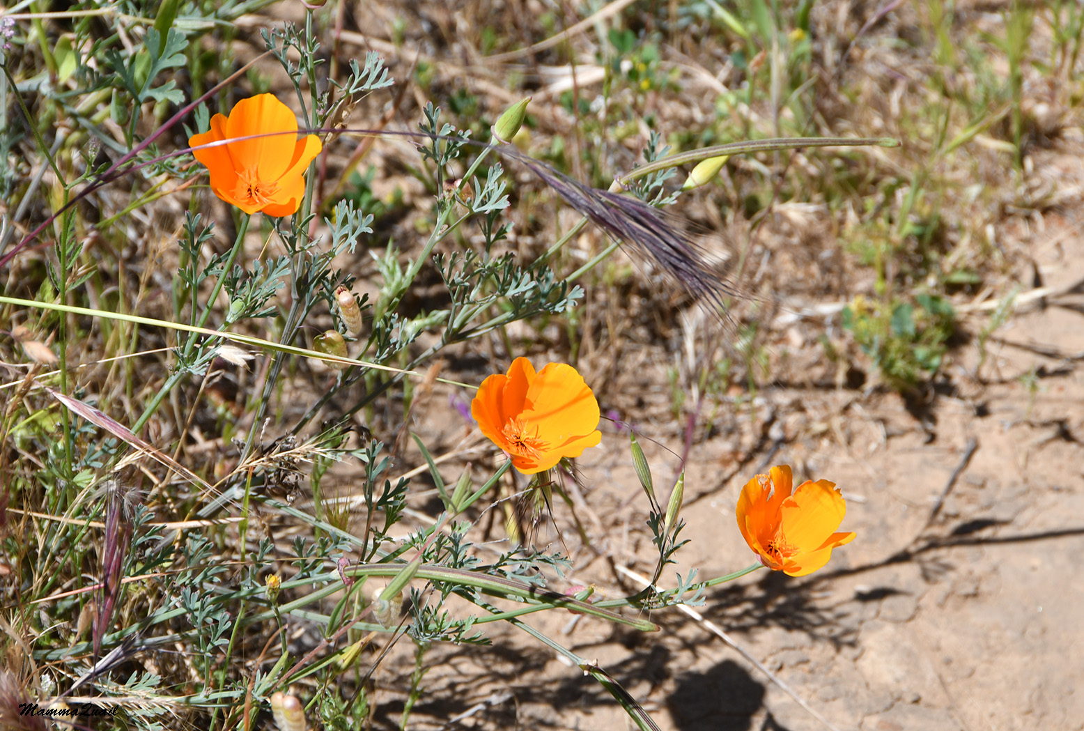
 |
| California Poppy, Eschscholzia californica |
The silence didn't last long: soon I heard the shrill whine of bike wheels zooming downhill at top speed. I couldn't help myself and squealed "wheeeeeeeee!" as the biker zoomed past me.
 |
| Blue-eyed Grass, Sisyrinchium bellum |
The bikers were not only on the paved road. I encountered a few dirt bikers on the Summit Trail where in the narrow segments I had to escape from into the vegetation hoping not to fall into any ground squirrel hole.
 |
| The Summit Trail |
I don't remember much from the first time I ascended Mount Diablo, about 20 years ago. The strongest memory I have of that hike was the grass covered slopes shining in the sun and rippling in the wind. I didn't realize at the time that all this grass was invasive in California. Going through the same trail segment again I now was aware of that, but still enthralled by the beauty of this scenery.
A slight movement on the trail caught my attention: it was a spider, striding away on the trail, completely exposed. It didn't seem to mind me as I hunched over to take its photo.
Mount Diablo has a complex geological story. In a nutshell - it rose from an already messy part of the Earth's crust with added touches of twists and faults, and topped with erosion forces. Explanations of that are posted throughout the Trail Through Time which overlapped the Summit Trail east of the South Gate Rd.
 |
| The Summit Trail/Trail Through Time |
The vegetation flanking the trail looked all dead and dry but a closer look revealed quite a few plants that were green and even blooming. The hair dos of the chickpea lupine extended over the short, stubby ad pretty inflorescence.
 |
| Chick Lupine, Lupinus microcarpus |
Tiny blue star-like flowers beaconed me from a small mound some distance from the trail. These were hard to get to without leaving the trail altogether, and they were masked by the stems of their neighboring grasses.
 |
| Purple Navarretia, Navarretia pubescens |
Common along that trail segment however, was the gumweed, which looked like not having reached peak bloom yet. The gumweed flowers attracted many butterflies.
 |
| A checkerspot butterfly visiting Gumweed, Grindelia hirsutula |
The rail sloped some, then leveled some, then sloped some more. I left the open grass ridge and now was walking in chaparral again. A little different chaparral than earlier - this community had much poison oak, elderberry, sticky monkey flower, and sage brush.
 |
| The Summit Trail/Trail Through Time |
I saw a slight movement from the corner of my eye. When I looked directly at where the movement was I saw a large, hairy caterpillar in a threat pose. I thought that if t wouldn't have puffed so, I would never have realized it was there at all.
 |
| Caterpillar of a Western Tussock Moth |
The caterpillar was cute but nearly all being of its kind I've seen on this hike were already in their mature phase.
 |
| Variable Checkerspot |
Summit Trail: From Summit Road Junction to Mount Diablo Summit
The trail reaches the Summit Road near the meeting of the North Gate and South Gate roads. Near the connection there is the Sunset picnic area. It was deserted when I arrived there, and it was shaded. I was relieved to be able to sit comfortably in the shade, eat my snack and rest a bit. The heat was heavy.
I let my thoughts drift as I was sipping my water. The last time I summited Mount Diablo was 17 years ago. I was with a friend and we begun our hike at the North Gate. It was here at the junction that we connected to the Summit Trail to complete the climb. It was around the time time of year and I remember it being a hot day as well, but I think I fared a little better in heat then than I do now.
I came out of my reverie when I noticed a tiny red dot roaming on the picnic table I was sitting at. Suddenly I had the energy to jump up and check myself all over.
 |
| Chigger |
After seeing the mites on the picnic table I decided I've had enough rest. I got up, crossed the Summit Road, and moved onto the dirt road that split from it where the Summit Trail continued upslope. I passed a (ranger's?) residence on my way, and some distance higher up I came upon a historical sign post about an historical building that used to be there where the old junction trail led to - the Mountain House Hotel. It didn't seem as if anything remained of that hotel.
The the grade of the slope increased and human artifacts (other than the trail) were left behind me. The trail, still a fairly wide dirt road, was going up a narrow valley and there were many wildflowers blooming by the trailside, including large patches of the lovely foothill penstemon.
 |
| Foothill Penstemon, Penstemon heterophyllus |
There were also a couple more geological information posts, and several places in which the rocks were exposed to shoe the twisted layers of Franciscan chert. There would be more of these, and much larger too, near the summit.
Half a mile later I crossed the Summit Road again, and again I had to dodge a few bikers who rushed downhill without seemingly using the breaks.
 |
| The Summit Trail |
The next segment of the Summit Trail was a narrow foot path going through chaparral which was composed mostly of chamise, hop tree, and yerba buena. The yerba buena was at peak boon and attracted so many pollinators that the air was buzzing constantly with insect clouds.
 |
| Yerba Santa, Eriodictyon californicum |
The Summit Trail no longer overlapped with the Trail Through Time. That continued on the Juniper Trail on which I'll be going back down later on. I was pretty high up by now, and had a magnificent view to the southwest where I could see the San Francisco Bay far below.
 |
| View to the southwest |
I was also alone on the trail. The few other hikers that I've seen past the Staircase Trail didn't not continue any higher. At least none that I could see. I was all alone on the trail.
There were barely any trees by the trail now, save for an occasional Coulter pine with casts a rather ineffective shade. I paced myself slowly, stopping frequently to bring and wipe the sweat off my face. I also took many photos, exuding my slow pace with the need to capture as much of the grandeur of this hike as I could.
 |
| California Juniper, Juniperus californica |
Slowly, as I followed the curve of the trail, the summit of Mount Diablo came into view for the first time during this hike. The tip of the beacon building (in the middle of the photo below) looked both far and near. There was still some distance and height to cover and I was already tired and too hot, but it was also not that far and the sight of the summit gave me a well needed boost of energy.
 |
| Summit View |
It also helped that the trail's grade was much milder now, and that a light breeze eased the intense heat off my body. Ut also helped to see that at this height spring was still on and the plants were at peak bloom. Blooming chaparral is a true celebration for the eyes and the ears!
 |
| Golden Eardrops, Dicentra chrysantha |
Not everyone shuns the heat. As I walked past a dead tree I sensed I was being watched. I looked up expecting a bird but what I saw was a lizard, perched well above me on the dry log. We looked at each other fir a few long moments before I moved on.
 |
| Western Fence Lizard |
Then I felt something landing on me. I shook it off- it was an earwig. I dismissed it as an incident of the wind lifting one and randomly dropping it on me, but soon I felt more of these, and I begun to see more and more earwigs out in the open, on the chaparral plants and on the trail itself. I thought that was really unusual because I never see earwigs out in daylight like that, and certainly not in big numbers. I wondered if they have a mating season in which they go on a mating swarm. I didn't even know they could fly.
 |
| An earwig (male) on chamise. |
I read about earwigs later and confirmed that earwig swarming was indeed an unusual occurrence.
I didn't think the earwigs did any pollination although I did find a few inside some flowers.
The chaparral plant community I was walking through consisted of thigh-high shrubs which was nice, because my eyes were higher than the vegetation and I could see all the vines and creepers that rode the hardwood shrubs.
 |
| Smooth Western Morning Glory, Calystegia purpurata |
The pipestem is an early bloomer and while I did see some blooming still, most of them were already fruiting. Not yet ripe and all feathery, but already assuming the sweet 'Traffula Tree' looks.
 |
| Pipestem, Clematis lasiantha |
The elderberry tees near my house were already bearing fruit but up at the heights of Mount Diablo, the elderberry was too at its peak bloom.
 |
| Blue Elderberry, Sambucus nigra ssp. canadensis |
Although this segment of the Summit Trail no longer overlapped with the Trail Through Time, there were still plenty of very visible evidence of the mountain's crazy geological story. I'm not very knowledgeable in geology but I do find these rock formations very alluring and beautiful.
 |
| Layers of Franciscan Chert |
As I continued my progress uphill and around the contour to the southwest-facing slope the chaparral subsided and the scenery changed to open, rocky terrain with smaller shrubs and patches of annuals. I saw many chia heads along that trail segment but all of them were past their bloom time. I did find one chia plant with a single flower on still and considered myself lucky.
 |
| Chia Sage, Salvia columbariae |
One of the most common wildflowers in California, one that I see nearly on every hike, is the Yarrow. I almost never photograph it anymore, noticing it only as a matter of fact. There were so many of them along the Summit Trail however, and they looked so beautiful at their peak bloom, like little floating clouds, that I couldn't ignore them.
 |
| Yarrow, Achillea millefolium |
It was also at this elevation that I started to see the California native western thistle blooming on the rocky slopes. On those that were close enough to the trail I could see many pollinators crawling.
 |
| Western Thistle, Cirsium occidentale |
It was also up there that I saw the fifth species of mariposa lily that day and my heart jumped with joy. Five different species of Calochortus! That's the most I've ever seen on any single hike!
 |
| Butterfly Mariposa Lily, Calochortus venustus |
Of all the segments of the Summit Trail, this one, from the second crossing of the Summit Road to the summit itself, was the richest in wildflowers, both rare and common. I forgot the heavy heat and had a blast just looking at the wildflowers and the wild pollinators going crazy over them.
 |
| Silver Bush Lupine, Lupinus albifrons |
Many of these wildflowers blended perfectly with the dry grass background, not creating strong colored patches. there were however, many blooms between the dry grass blades.
the pink spineflower for example, not very conspicuous in the dry grass but lively and very pretty to look at from a close distance.
 |
| Pink Spineflower, Chorizanthe membranacea |
The same applied to the dense owl's clover which is a small plant, usually not very visible in a field of tall dry grasses.
 |
| Dense Flower Owl's Clover, Castilleja densiflora |
I walked past another dead tree and noticed a female hummingbird perched on top. I raised my camera and as I was photographing a second female hummingbird swooped by, scaring off the first one and taking its prime perch location. The photo below is of the second bird after the successful usurpation.
 |
| Anna's Hummingbird, female |
The trail curved around the contours of the south-facing slope. The scenery here was much drier and the trees fewer and far between. Most of them were low junipers, and there was much activity of scrub jays in their branches. I couldn't see them very well, let alone photograph, inside the dark green dense branches, but I hear them all right - they are very noisy birds.
 |
| California Juniper, Juniperus californica |
I arrived at the last segment of the trail where it curves sharply to the west to meet with the Summit Road at the Lower Summit parking lot. Ahead of me I saw a few other hikers - I was surprised to see them there because up until then I was completely alone on the trail. These hikers didn't follow the curve but continued up the same trajectory up the rocks, directly toward the summit. When I got to where they were I saw that there was a trail there - thin and unkempt, but clear and well established. It was a direct route to the summit and it was partially shaded by the large rocky ridge. I felt too tired and overheated to take the longer and sun-exposed route so I followed the path the other hikers took.
 |
| Summit View |
All the way up I was certain that after reaching the summit I would go around the Mary Bowerman Loop that goes around the summit through all the summit area's plant communities and 360
° views. As I was climbing the last lag of the trail toward the summit I had second thoughts about adding this loop. The intense heat affected me and I took longer time than I expected to hike up the mountain. Besides, I've
hiked the Mary Bowerman Loop many many times already, in every season around the year. I finally decided to skip it this time around.
 |
| The south pillar |
One unexpected reward for taking the rocky shortcut was seeing the Abrams' dudleya blooming on the broken chert all the way to the summit.
 |
| Abrams' Dudleya, Dudleya abramsii |
Near the end the unofficial trail curved east, coming by the south pillar, crossing the Mary Bowerman loop at that point, then going straight up through the rocks o the light beacon building. The sun was already dipping in the western sky and as I was climbing from the east, it was shining right into my eyes and my camera lens. I kept my eyes down on the trail and raised them only when I reached the shadow of the light beacon. From there all I needed was to go around the building to the upper summit lot.
The account of this hike is very long and fearing one post might be to heavy to upload I spilt it. This story
continued here.


5 species?! wow!! good for you! looks like a very long and strenuous hike, especially when it's so hot. but so beautiful!
ReplyDeleteI was very excited about seeing so many Calochorti on that one hike! When the road is open one doesn't have to hike all of this trail to see them - you can go in with the car and get to the places of bloom with shorter hikes.
DeleteThis is one of the greatest posts in your blog, in my opinion...
ReplyDeleteMake me want to visit there :-)
Five different species of Calochortus is wonderful - I especially liked the Splendid Mariposa Lily and the Mount Diablo Globe Lily.
Thanks! IIt was one of my greatest hikes too :-) And yes, you should visit it, I'd love to show you around!
Delete