Monday, March 10, 2014

Hot, Hot, Hot: an August Hike to Bear Canyon and Switzer Falls

Date: August 22, 2013
Place: Colby Canyon and Switzer Falls, Angeles National Forest, Los Angeles, California
Coordinates:  34.26633, -118.14570

Difficulty: moderate (strenuous when hot)Length: about 4.5 miles

Last time we've been to Los Angeles, our good friend there showed us around and took us hiking at Solstice Canyon. This time, he was going to take us into Angeles National Forest, to one of his favorite trails: the Gabrieleno Trail to Switzer Falls.
We met at the hotel where we stayed and drove in a convoy into the San Gabriel Mountains. It was a slow drive and our host stopped to show us the after effect of the fire that incinerated the area in 2009. That fire, started by arsonists, had claimed 3 human lives and consumed 650 square kilometers and was the largest in California's history until the Sierra fire of last summer had surpassed it.
Bear Canyon had survived that fire. Deep enough and wet enough, the vegetation there was spared. We parked at the staging area and started walking along the creek.
Blessed shade in a hot day: the trailhead. 
Even in mid-August, the creek was flowing. It was nice to walk in the shade where everywhere else was unbearably hot.
Ripples and Light
The heat didn't bother the lizards. They cherished it.


We met quite a few lizards along the trail. Some were gracious enough to let us photograph them.
 

Whenever I lifted my eyes and looked through the trees I could see the charred evidence of the fire. Such devastation, so close.

Near the water, though, the trees were vital-green, shrubs were blooming and birds were twitting. It was life as usual.
Poplars by the creek
I was actually surprised to see flowers this late in summer. They were right by the water, though.
Fleabane (Erigeron brewery)
The fleabane is local. The chicory is an immigrant.
Chicory (Chicorium intybus), and invasive species
The trail to the falls goes up the hillside, which meant leaving the soothing shade and get exposed to the blazing sun, enhanced by the albedo off the white rock. The vegetation changed too: we were now surrounded by agave, toyon and yucca.
Chaparral Yucca (Hesperoyucca whipplei)
One particularly pretty sight was the mountain mahogany, displaying its feather-like seeds in the blazing sunlight.
Mountain mahagony (Cercocarpus betuloides)
The feathered tails allow the seeds be carried in the wind. Until then they give their mother bush a very angelic look. 
Mountain mahagony (Cercocarpus betuloides)
And another seed display that caught my eye: 
Hollyleaf Redberry (Rhamnus ilicifolia)
In this case the seeds don't go anywhere with the wind, but are carried off by birds who eat the red fruit. 
There were also dead, blackened trees all around. We were happy to go down into the canyon and be back in the shade.
Raven on a charred tree branch
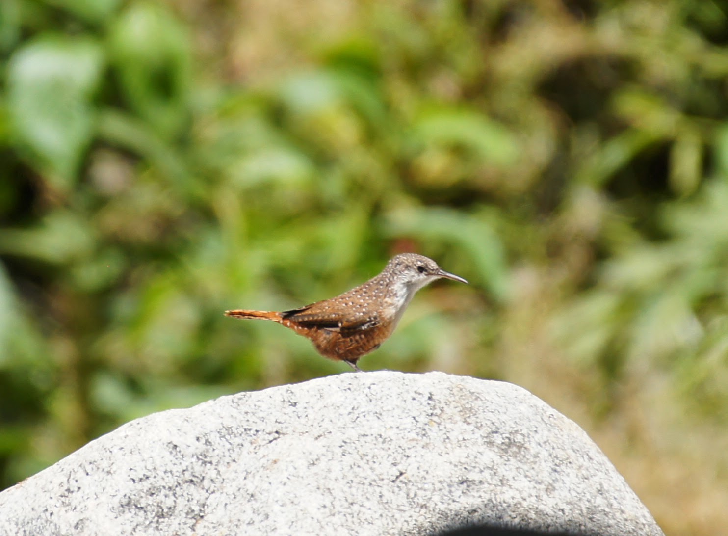
A short walk along the second canyon and we found ourselves by a little pool at the bottom of the lower of the Switzer Falls. We were delayed but a little, when Papa Quail noticed this canyon wren displaying on a nearby rock:
Canyon Wren
But even the wren couldn't hold us long.  A few minutes later we were sitting by the cool of the pool.
The bottom pool of the lower Switzer Falls. 
The chikas were quick to dip their feet in the water. Papa Quail and I followed our guide and climbed to the upper pool at the top of the fall, which was a bit of a risky business. Grandma Quail stayed and watched the chikas.
The top pool of the lower Switzer Falls. 
We didn't go on to the upper falls. That would have been too much for our heat-exhausted company.
It was high noon and very high heat. It took a great mental effort to get away from the cool of the pool and head back up the exposed hill. The chikas were rebellious, which added to the naturally-difficult conditions. We were very fortunate though, to have our friend guide us on that trail. He knew exactly where to stop and show us another fantastic feature of that trail: the Echo.
Sorry, no echo photo, but that's the magic spot.
We stopped on that spot and for a good long break, stood there, yelling, howling and making all kinds of vocal expressions at the opposite canyon wall. The echo was so clean and impressive that we did it for quite a while. The chikas (all of us, really) felt much better after that stop. We continued back to Colby Canyon and up the creek.

Bear Creek water flow
I just can't understand why anybody would want to hike in Nature while carrying a loud boom box with them. Luckily, those we've seen (and heard for a long while) on the trail were going the opposite direction.
We were drenched in sweat when we got back to the parking lot. The trail is beautiful. I would love to hike it again. Probably not in August, though. But Spring Break is coming soon ...

Many thanks to my friend, Green Thumb, for sharing with us the Nature treasures of Los Angeles County and for his wonderful company!

Many thanks also to members of the California Native Plants Society for their help in identifying plans!

A view of Colby Canyon


Friday, February 28, 2014

The Balconies of The Pinnacles National Park

Date: August 17, 2013
Place: Pinnacles National Park (west), Soledad, California
Coordinates: 36.4918, -121.2097
Length: 2.6 miles
Difficulty: Moderate to strenuous (involves rock scrambling and a narrow staircase).
Comment: Flashlights required if entering the caves.


Since we moved to California I had visited the Pinnacles National Monument several times. Recently, though, it has been promoted to a National Park. Last August, en-route to our revisit of the Channel Island NP with Grandma Quail, we had the chance to stop on the way and show her the latest addition to the glowing list of California National Parks.
The brand new visitor center on the west side. With the updated sign.
Visiting the Pinnacles in the height of summer isn't necessarily the wisest of ideas. Nestled in a mountain range once removed from the coast, it can get very, very hot there. Still, we went there and yes, it was very hot :-)
A Pinnacle
The park is named after the massive rock jags that are the remains of an inactive volcano, which was split in half and moved to its current position by the San Andreas Fault. These pinnacles of rock can be seen briefly from Hwy 101, but otherwise they are hidden in the mountain range.
More Pinnacles
Not quite the desert, The Pinnacles is fairly dry. By mid-August the annual plants were all brown and the bushes displayed a variety of colors ranging from rusty to dark green. The trees there are far apart  and each of them stands out in character.
Live Oak
Coming from the west and not planning to stay, we chose to hike the caves and balconies loop trail.
Map section scanned from Tom Harrison Maps' Pinnacles National Monument map. Our trail is labeled yellow. 
After walking for half a mile under the sun we entered boulder area. The creek narrowed into a canyon and the trail went over and between some very large boulders, many of which were decorated with colorful lichen growth:
Lichen on the rock
When we got to the loop we took the right trail, leading directly into and down the caves.
In a hole in the ground there lived ... bats. Sometimes.
These caves are not curved inside the rock. They were created when massive boulders fell on top of the canyon, roofing it. Except for the occasional skylight opening it is dark inside, and the trail can be tricky and slippery.

We took our time to carefully climb the narrow, dark trail.
Light at the end of the tunnel
Waiting for us, after emerging from the cave, were pretty red flowers that grew at the bottom of the stairs.
Hummingbird Trumpet (Epilobium canum)
The Hummingbird Trumpet wasn't the only red color there. The Poison Oak can get quite red too.
Poison Oak being festive
Very few plants were blooming at the time. And even those that did, were at the very end of it. Like this broomrape, a parasitic plant that instead of photosynthesizing, lives on and off roots of nearby plants.
Jepson's Broomrape (Orobanche californica ssp. jepsonii) 
There were many of the cushion-like bushes of the Eastern Mojave Buckwheat, some were even blooming still:
Eastern Mojave Buckwheat (Eriogonum fasciculatum)
But most already wore the rusty-brown after bloom colors:
Eastern Mojave Buckwheat (Eriogonum fasciculatum)
It was very hot and we stopped to rest for a while in the shade. The Clematis stayed in the sun and the light shone through its fluffy seed feathers. They looked like little cotton-ball clouds.
Pipestem (Clematis lasiantha)
After going through the caves and up the stairs we turned left and up to the Balconies Cliff Trail. The Balconies are the cliff levels of the mountain to the west. They tower pretty high over the canyon.


The trail doesn't go all the way up there. Just along the lower balcony.
The Balconies
Up there, just before going round the curve back south, I glances north to the valley beyond the canyon. It was the closest thing to a forest that we saw that day.

As we walked along the lower balcony I noticed the dark, vertical lines in the rock: the marks of seasonal water flow.
The Balconies
Looking at the map now, I noticed for the first time that many of these pinnacles have been named. I wish I could remember which ones are these. Regardless of their name, they are all unique and awe-inspiring. And yes, people do go there to climb them. (But not in the middle of August, apparently.)
Toogs? Osiris? 
After almost a mile of walking along the balcony, the trail descends back into the canyon, some distance before the entrance to the caves.
A view south from the Balconies
The reason the place was upgraded from a National Monument to a National Park is that this place was chosen as one of the sites to re-introduce the almost extinct California Condor. We have seen them there in previous visits, and were hoping to see them again on this one too.
Not quite condors: Turkey Vultures circling the sky. 
But the condors were someplace else that day. We did get to see other birds, though. Little, evasive, and noisy. Good thing Papa Quail has patience for them.
Wrentit
Nothing as exciting as a bobcat on that hike for us. Just a cute little chipmunk. They always make me smile.
Merriam's Chipmunk
Back near he parking lot I took the time to photograph a member of the tarweed family that really caught my attention in our SoCal trip. I like the way the disc florets stick out like eyes from between the ray florets.
Three-ray Tarweed (Deinandra lobbii)
Despite the heat, we had a very nice hike at the Pinnacles. From there we continued south to spend the night in Ventura, where on the morrow we would embark on our cruise to Santa Cruz Island. About a week later we would come all around and return to the Pinnacles from the east on our way back home.


Many thanks to members of the California Native Plants Society for their help in identifying plants!


Thursday, February 6, 2014

An Impromptu Hike at Bothe-Napa Valley State Park

Date: January 20, 2014
Place: Bothe-Napa Valley State Park, Calistoga, California
Coordinates: 38.55120, -122.51997
Length: About 5 miles
Difficulty: moderate to strenuous

It being so soon after a long winter vacation, we didn't plan any big trip for the Martin Luther King's Day weekend. A one day hike was enough for us. I have planned to take my family to Angel Island so we packed up food and water for the whole day and we arrived on time to the Oakland ferry just to discover that it doesn't run to Angel Island until spring.
We stood at the depot with our full backpacks and wondered where to go next.
I was recently reminded of cedar waxwings and I recalled that the first time I ever saw these beautiful birds was at Bothe-Napa State Park, on a persimmon tree right by the visitor center. I immediately suggested that we go there.
It's been a few years since we've been there last. The chikas were very young and we didn't walk much. Now we had the opportunity to do a proper hike there.
The park is a bout 6 miles south of Calistoga on Hy 29 and it took us about an hour to drive there from Oakland. When we got there we found no attendant at the gate, a closed visitor center, and no brochures of maps available. Having gone there on an impulse we did not have the map with us and I wondered how far out we should go without one. Then I spotted a ranger coming to empty the self-registration stand and I approached him, asking for the park's brochure. He handed me a flyer with the map of the campground and the marking of the trailheads, which did not satisfy me. I kept asking questions about different trails and eventually he pulled his one copy of the park brochure with a detailed trail map from his vehicle and gave it to me.
American Robin, near the visitor center
As it turned out, The map was very useful (if the ranger happens to read this, thank you!), and not only for us. All along our hike we run into people who weren't sure where to go next. Based on this I'd say that people who plan to go hiking at Bothe-Napa Valley State Park (or at any other California State Park, I guess) would be prudent to download and print the brochure map before going.

Map portion scanned from the park's brochure. Our hike is labeled yellow.
The Ritchey Creek, along which we hiked most of the time, originates at a spring and has a year-round flow. It was nice to see running water in January of the worse drought year California is experiencing in many years.
Ritchey Creek
Although it was already late morning, it was quite cold when we started on the trail. We had planned to be under full sunlight in Angel Island and were not prepared for the deep chill of the shady woods. All of us were huddled in our light sweaters and I hugged my chikas on both my sides and urged them to walk quicker. Eventually we run into a small, but effective ascend that had warmed us up enough.
Occasionally too, the sun rays broke through the canopy and lit up patches of the forest. At that point I got warm enough to pull my hands out of my sleeves and turn on my camera. As always: the pretty bark of a madrone tree made the perfect photo subject.
California Madrone (Arbutus menziesii)
The park prides itself on the redwood trees. Although we did not see any giants, even the younger, slimmer redwoods are impressive.
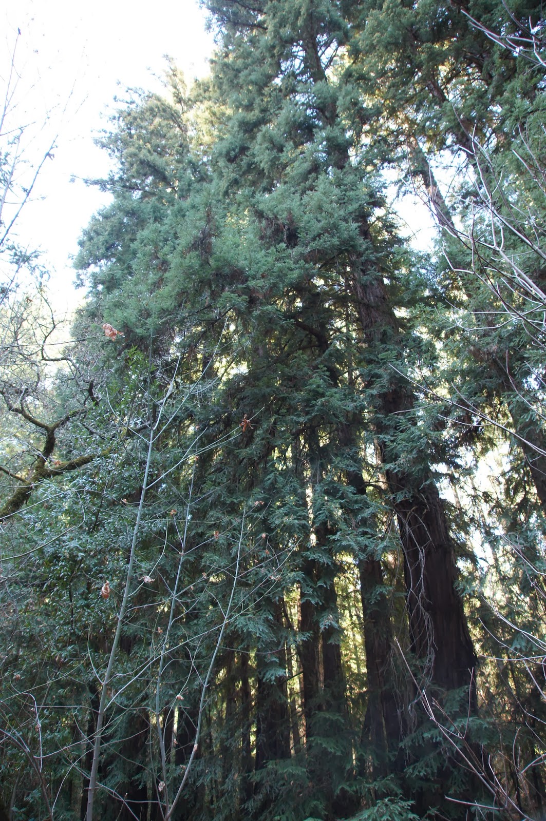
Redwood (Sequoia sempervirens)
We went on along the creek going up at a gentle slope. We originally took the Redwoods Trail, which goes along the southern bank of the creek, but all the time we had in view the wider Ritchey Canyon Trail that went parallel to us along the northern bank.
At some point the elder chika announced that she saw a cat on that trail, across the creek. I lifted my binoculars to my eyes and couldn't believe our luck: for the second time in two months I was looking at a bobcat. And this one, too, was nonchalant. Walking to and fro, aware of our presence but not caring all that much. Not enough to run away, anyways.
Humans? Bah!
Papa Quail was busy photographing the cat with every move it made. Eventually it started trotting down the trail in the opposite direction of our hike. Papa Quail followed along on our side of the creek and when he got tired of photographing the cat's behind, he whistled.
And the cat turned its face to the camera :-)
Seriously? A whistle? What am I, a dog?
That truly was the turning point of the hike. Suddenly the chill was forgotten and all the whines and complaints quelled. Giddy and excited we dashed along the trail, ready to meet the next surprise. 
The Redwood Trail ands at the creek. We crossed on the rocks and met with the Ritchey Canyon trail. Then we had to decide weather to loop back to the car or go on forward. At that point I was really glad that I got the map from the ranger because without knowing where the trail was headed we would have certainly gone back at that point.
The end of Redwood Trail
We went on uphill, joined by two other hikers who had no map and did not want to stray too far. Soon, the Ritchey Trail forks. We took left (straight, really) onto the wider Spring Trail, which crosses the creek on a small bridge, and continues uphill in steep slope. At the end of Spring Trail there's the actual spring, all fenced away. At that point the trail suddenly narrows and disappears between the trees. We followed the trail in a single file all the way uphill. At the meeting point with Ritchey Canyon Trail the forest becomes chaparral and the view opens up.

This was the only true sunny spot in our entire hike. And it isn't a convenient stopping place so we didn't stay there for long. Just enough to notice this pretty hummingbird, enjoying the warmth:
Anna's Hummingbird
We started downhill on the Ritchey Canyon Trail and immediately plunged back into the woods. The trail segment all the way down to the first creek crossing is very steep and slippery and caution should be taken going down there.
Despite the drought, the forest air felt cook damp. Many of the downed wood had fungi growing on them.
The fungi, an essential component of the forest ecosystem, decompose dead organism and release the nutrients back into the ground to be used for new growth. The fungus lives its life underground or within the dead wood, out of sight. Unless, of course, it's fruiting.
Fungi fruiting bodies growing out of a felled tree.
The shade was thick and there was very little undergrowth. Of what did grow under the trees, I found this delicate plant the prettiest, even without its inside-out flowers:
Insideout Flower (Vancouveria hexandra)
After crossing the creek the slope became gentler and the trail widened again. We continued walking on the north side of the creek and Papa Quail continued searching for the little brown birds that chirped in the vegetation. Eventually, with a lot of patience and some luck, he spotted one that was staying put long enough to be photographed:
Fox Sparrow (Sooty)
We didn't run into the bobcat again. More and more hikers were coming up the trail, though. Soon we were going past the Hitchcock Site, where the area's once owner used to have a home, and past the campground.
At the Hitchcock Site
Half a mile of an easy walk later we were back at the staging area. I wasn't sorry one bit for missing out on Angel Island. It would wait for another day. We've hiked in a beautiful redwood forest and seen a bobcat: what more could I ask for?
Creek and Redwoods and what turned out to be a very nice day.
And, yes. We did stop at one winery on the way back home. We were in Napa Valley wine country after all.

Many thanks to members of the California Native Plants Society for their help in identifying plants!